EUROPE –
PART 6
The contrast between Skye and the Uists is striking, and you see it as soon as the ferry docks at Uig. The island is part of the Inner Hebrides group and is slightly smaller in area than Prince County on Prince Edward Island, with a population of about 10,000. Unlike the other islands on our tour, it is connected to the mainland by a bridge. The main industries are tourism, agriculture, fishing, aquaculture (salmon), and forestry. There are browns and greys in the landscape, as on the Uists, but these are complemented by vivid greens like we’ve seen in Ireland and on the South Island of New Zealand. And, best of all, most of the roads are double track!
We spent two full days on Skye, starting with a stop in Portree, the main town, and a visit to the local Tourist Information Office where we were advised on what to see in the short time we had. Our hosts, Hayley and Thomas of the Kilcamb B&B in Edinbane, suggested we drive to Carbost and have dinner at the Village Inn rather than go back to Portree. “You’ll be sure to get a table there,” they told us. Tourist operators here have been having a difficult time finding staff since COVID, just as they have back home, and many restaurants are closed. To illustrate, the place where we ate on Benbecula featured a waitress from Portugal and a waiter from Romania. By the way, the Village Inn turned out to be a beautiful spot: good food, lots of character, and right beside beautiful Loch Harport. Lesson learned: always take advice from the locals on where to eat and what to do.

We’d planned to see four attractions during our one full day on Skye and started with a visit to the Skye Museum of Island Life. There we learned what a ‘crofter’ is, how difficult life was in olden times, the story of Bonnie Prince Charlie and the Jacobites, and why Scots left for the New World during the Highland Clearances, many of them to settle on our Island. The museum’s collection of buildings, tools, and artifacts is excellent. Fortunately, we got there just before a busload of tourists and were able to take our time discovering. Shown below are the crofter's cabin of John and Annie Graham, who raised ten children there and, of course, the handsome Highland cattle that are common on Skye.


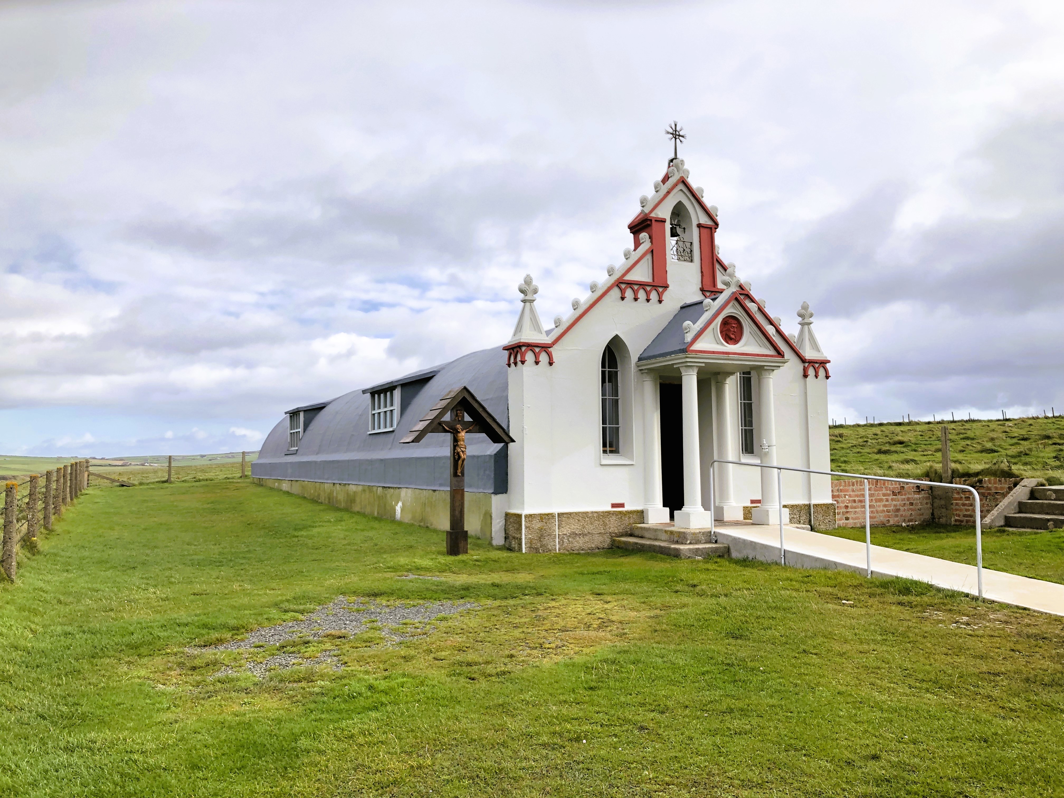
We stopped at Kilt Rock and Mealt Falls. The rock
is 90 metres high and consists of basalt columns sitting on a sandstone base. As
the photo shows, the pattern looks like the pleats of a kilt, hence the name. Mealt
Falls plummets from the top of the cliffs into the ocean below. Together, they
are an impressive sight.


Next, it was on to the Storr, an impressive rocky outcrop located on the east side of the Trotternish Peninsula overlooking the Sound of Raasay. The parking lot was near full as we began our two-hour hike to the base of the Old Man of Storr and its neighbour, the Needle, so-called because of its sharp point and its ‘eye’. I’m not sure what the difference in elevation is but I know my Garmin showed we’d climbed 100 stories. The Storr and the Needle are impressive sights, even in the horizontal rain that greeted us just as we arrived at our destination. The third photo shows Elva on her way down; easier said than done on slippery rocks when you're well past your best before date!


Stop number four was the village of Sligachan, trailhead for the many paths through the Cuillin Hills. We had planned to take a short hike to the Fairy Pools, a series of deep pools fed by waterfalls, but the trail was just too muddy and, anyway, we’d had enough exercise for one day.
On the morning of our last day on Skye, we drove to the westernmost point on
the island, Neist Point Lighthouse, and on our way back toward the ferry,
visited the magnificent Dunvegan Castle, ancestral home of the MacLeod Clan.

We arrived at the ferry terminal on Harris at 9:00 pm and drove through driving rain on unfamiliar roads to our B&B near Stornoway, largest town in the Outer Hebrides, population 7,000. Thank goodness the road was two-lane. Next morning, we headed west on Lewis and stopped to visit the Calanish Stones, a circular arrangement of thirteen boulders surrounded by five rows arranged in a cross shape. They were erected about 5,000 years ago, making them older than Stonehenge. Although their purpose is unknown, they are an impressive sight. Humans living in other parts of Europe at the same time erected standing stones, both singly and in groups.

Continuing westward, we visited the Blackhouse Village, a collection of traditional stone houses with thatched roofs lovingly preserved for visitors and those searching for a unique living experience. One of the structures was occupied by a family until 1974 and has been preserved just as it was. The floor is slanted so that the manure of livestock that lived in the lower part of the structure would flow in the right direction, away from the house’s human occupants, obviously. Several houses on the site have been repurposed into self-catering accommodations, an important source of revenue for the trust that manages the site. Incidentally, they’re called ‘blackhouses’ simply because they differ from the more modern houses on Lewis, most of which are painted white.

We also learned about peat: how it’s cut, dried, and stacked. The man in the first photo is loading peat from a trench where he’s cut and dried it. He’ll take it home and stack it in his yard as shown in the second photo.


As is our usual habit, we went to the end of the road, the north end of the island and the community of Ness. We found a small beach there beside the tiny fishing port. The wind made for some impressive surf conditions. That afternoon, we toured Stornoway, a town founded by the Vikings in the ninth century and had lunch and dinner there.
On our second day, we’d planned to drive to the village of Tarbert as Elva wanted to check out the world-renowned Harris Tweed shop there. After breakfast, we went to put on our hiking shoes in the entryway to the B&B. No shoes! What the hell? Panic! My Merrells were all of four days old and Elva had owned hers for barely a month, complete with custom-made orthotics. All gone, easily $600 worth of footwear! As it turned out, guests who’d checked out that morning had taken the shoes by mistake and were heading towards the ferry on South Harris. Our host, Helen, tracked them down by phone and arranged for them to drop off the shoes at the Harris Tweed shop in Tarbert. We were some glad to see our precious footwear waiting patiently for us when we got there! Today’s lesson: “Don’t sweat the small stuff!”

After a few more kilometers of single-track on the tiny Isle of Scalpay (village shown on photo below) and on South Harris, we returned to Stornoway for one last night at Lathamor and enjoyed a delicious meal prepared by Helen, thus far the best we’ve had in Scotland.

The next morning was windy and wet (again) but the ferry was running from Stornoway to Ullapool on the mainland. Our plan for the day was to drive two stretches of the North Coast 500, Sutherland and Caithness. The North Coast 500 is a 500-mile road trip through the North Highlands. It reminds us of the Cabot Trail and the Gaspé Peninsula with a bit of Québec’s Basse Côte-Nord added for good measure. Unfortunately, we didn’t see much of the landscape for the first few hours because of rain and fog but the weather did finally clear when we reached the village of Durness. Here, we found these most impressive stone fences (Who needs guardrails?) and, nearby, visited the magnificent Smoo Cave and a lovely beach.


By the time we arrived at our rest stop for the night, Westlea B&B in Thurso, I’d had enough single-track for the day. The North Coast 500 is a very busy road, even at this time of year, and I met far too many RV drivers who left me almost no room to pass.
We awoke to bright sunshine in Thurso for the first time in many days. The ferry Hamnavoe, as luxurious as a small cruise ship, took us from Scrabster on the mainland to Stromness on the Orkneys. From there, it was a short drive to the main town, Kirkwall, population 8,000. The Orkneys lie 15 kilometers north of mainland Scotland and consist of 70 islands, 20 of which are inhabited. Together, they have a total land area about one-half the size of Prince County, and a population of 25,000 or so.
The landscape on the Orkneys is pastoral and the land is rich, surprisingly so for this far north, at the same latitude of the northern boundaries of BC, Alberta, Saskatchewan, and Manitoba. For the first time since southern Scotland, we saw fields that had been in crops, cereals mainly and a few rutabagas, and cattle are almost as numerous as sheep. The land is hilly, not mountainous like it is on the mainland and in the Hebrides. In addition to the natural and built environment, there are many layers of history here: Neolithic, Iron Age, Early Medieval, Viking, Scottish, and World Wars I and II.
The excellent guide at the tourist information office gave us an itinerary for the four days we’d spend on the Orkneys. We started by taking a walk around downtown Kirkwall and visited St. Magnus Cathedral (here shown at dusk), founded in 1137, and Britain’s most northerly cathedral.

To take advantage of the fine day, we set off for our first stops, the UNESCO Heart of Neolithic Orkney World Heritage Sites. The one I really wanted to see was Skara Brae, the Neolithic village. Along the way, we stopped to see the Standing Stones of Stenness, and the Ring of Brodgar, both impressive and similar to what we’d seen at Calanish on Lewis.

Skara Brae has an interesting story. The site was discovered in the 1850s when a storm washed away part of a bank and uncovered ten clustered houses made of flagstone. Archaeological research found that the site was occupied between 3,180 and 2,500 BC. That’s at least 5,000 years ago, and before Stonehenge and the Great Pyramid were built! Skara Brae is Europe’s most complete Neolithic settlement. The first photo shows the interior of a reconstructed house (shelf facing, hearth in the middle, and beds on either side) and the second shows the real thing. Amazing!


Near Skara Brea and the standing stones, we visited the Brough of Birsay, an uninhabited island we accessed by foot at low tide. It was first fortified by the Picts, early inhabitants of the northern and eastern areas of Scotland, in the seventh and eight centuries. They were displaced by the Norse in the ninth century and traces of the Viking settlement remain, including the church and a monastery. Nearby, I walked through the ruins of the Broch of Gurness, first settled around 500 BC; an impressive span of human history in an area no bigger than the Région Évangéline.


On Day 3 on the Orkneys, we took the tiny ferry to the Isle of Rousay where we planned to do the Westness Walk, described as the most important archaeological mile in Scotland. Rousay is a small island, home to 240 hardy souls, most of them engaged in raising sheep and beef cattle. We pulled into a small parking area and looked down toward some ruins and a building that resembled a farmer’s barn. It didn’t look like much from high on the hill, not even a path.

The Midhowe Chambered Cairn is a 5,500-year-old communal burial chamber that, until the 1930s, appeared to be nothing more than a large oblong grassy mound at the bottom of a farmer’s pasture. Local whisky magnate, Walter Grant, paid out of his own pocket to have the mound excavated and to build a large stone-walled hangar to protect the site.


People here have an appreciation for history that is unfortunately not found everywhere. Abandoned houses and outbuildings are left to decay in place. They are not knocked down, perhaps out of respect for the people who worked so hard to build them or perhaps in the hope that, someday, someone will come along and rescue them. We should have tried harder to protect our built heritage in La Région Évangéline. Those who, like me, mourn the loss of Église Saint-Philippe et Saint-Jacques will understand what I mean.

No comments:
Post a Comment