Thursday, 19 December 2024


SOUTH AMERICA – PART 6 

Before leaving on a trip, Elva and I do our research; YouTube is our favourite go-to source for information. On a cruise, we also check to see what shore excursions are being offered, since those also give a good idea of what’s worth seeing. So, for Ushuaia, we decided the best option would be to book an excursion through Viator to ride the Tren del Fin del Mundo (Train at the End of the Earth) and see Tierra del Fuego National Park. Boy, were we wrong! First, Ushuaia, our first landing in Argentina, turned out to be a beautiful city, framed by snow-capped mountains and well worth spending a day exploring on foot. Second, the train ride was one of the worst rip-offs we’ve encountered in all our travels. The lesson is that you can’t win em’ all and that you must turn the page and look forward to what tomorrow will bring.

Tourism is big business here and the city of 80,000 or so looks very prosperous. The view from the harbour is very inviting, unlike many other places we’ve visited. Two ships moored beside us were loading for departures to Antarctica, and we learned that as many as 600 cruise ships call here each year. The stores are high end, as are the hotels and eating establishments. Although Ushuaia is literally the end of the South American continent and the place where the road ends, it doesn’t feel isolated in that way.

Early the next morning, the Oosterdam rounded Cape Horn through the Drake Passage, famous for rough water. We were fortunate to be able to see the headlands on a calm, clear day before heading out into the Atlantic on our way to Islas Malvinas, better known as the British Overseas Territory of the Falkland Islands. Argentina has long claimed sovereignty over the islands but, despite several attempts, has never been able to do so. PM Margaret Thatcher sent British warships and troops to the Falklands in 1982 and re-conquered them, albeit with considerable loss of life on both sides.

An interesting footnote to the islands’ history is that they were first colonized by the French in 1764. A group of settlers arrived there from Saint-Malo, calling the place Les Îles Malouines. Among them were survivors of the Acadian deportation, some perhaps my distant relatives. Most stayed only a few years, unable to make a go of it on the harsh, unforgiving landscape.

The weather gods were kind to us the day we stopped at Stanley, capital of the Falklands and only settlement of any size; 2,500 of the islands’ 3,500 permanent residents live there. Before arriving, we’d been told that the chance of being able to land is no better than 50:50. We tendered to shore as soon as we could and found Jimmy Curtis Tours waiting for us on the dock. Our driver, Lynda, soon had us underway, headed for the Volunteer Point penguin colony in an ancient thirty-year-old Land Rover. On our way there, we passed by Port-Louis where the French settlement was located. After the road ended, we four-wheeled over the roughest terrain imaginable for about an hour. Lynda told us she’d been over the track at least 200 times.

Seeing penguins was “bucket list” for Elva and we were treated to quite a spectacle. King penguins, the second largest species, wandered around the beach in groups, not seeming to know or care where they were going. Magellanics surfed and dove in the breakers, coming ashore occasionally. Further inland, we came to the king penguin colony, at least 3,000 strong according to Lynda. Words do not suffice to describe their “cuteness”. The first photo is of a pair of magellanics standing guard outside their burrow and the other two are of king penguins, looking almost human as they waddled along nonchalantly.

As you can see by what Elva is wearing, it was chilly! December 10 is like June 10 where we come from. The islands had had snow last week and this is what the beginning of summer looks like here. The landscape is bleak, reminiscent of Scotland’s Outer Hebrides; there are no trees and very little of the land is suitable for anything other than sheep pasture. Still, the people here seem to love the place and wouldn’t want to live anywhere else. Sheep farming and tourism are the main economic drivers and islanders seem to be doing very well financially.

After two days at sea, we docked in Montevideo, capital of Uruguay, South America’s richest and most stable country by far. The city is home to about 2 million of Uruguay’s 3.7 million people and is very European-looking. The central location of the pier made it easy for us to just walk around, and we spent an enjoyable day exploring on foot. The first photo is of Independence Square with the Salvo Palace in the background and the second is of the old market building, now home to shops and several restaurants serving the country’s specialty, beef.

We “disembarked” on a Sunday after fourteen very enjoyable days on the Oosterdam, a ship we’d love to sail on again, and made our way to our hotel in the center of Buenos Aires, our home for the last five days of this adventure.

Buenos Aires is the capital and largest city in Argentina, home to 14 million of the country’s total population of some 47 million. Argentina is classed as a developing country, but it has known some very dark periods, beginning in the 1930s, but has been relatively stable since 1983. The current regime came to power with a promise of budget cuts, and these have resulted in severe inflation and consequent devaluation of the Argentinian Peso. As is the case with Bolivia, everyone wants US dollars

Buenos Aires is a very modern and walkable city, although we were warned to stay away from certain areas. We spent or first day walking from the large square bordered by the Congress Building to the Government House, Casa Rosada, the “Pink House”, the President’s official workplace. The weather was beautiful, nice and warm after several chilly days in the south and on the Falklands. We also spent time in the Metropolitan Cathedral, home church of the Archbishop of Buenos Aires, a position held by the current Pope, Jorge Bergoglio, until 2013.

We don’t usually ride the Hop-On-Hop-Off buses in cities we visit but we made an exception in Buenos Aires, and we’re glad we did. We got off at five or six of the twenty-four stops and got our money’s worth. In the same way a cruise does, the stops gave us an idea of where we’d like to return. There’s a lot going on the La Boca neighbourhood, home to some colourful characters, real and imagined, and birthplace of the tango. And Buenos Aires has more park space and public art than any city we’ve seen in our travels.

We continued to explore Buenos Aires on our fourth day there with a three-hour guided walking tour of the Retiro and Recoleta neighbourhoods. It was excellent! During the guided tour, we learned more about the country’s economic woes. Runaway inflation is a recurring phenomenon in Argentina, the result of bad decisions by successive governments.

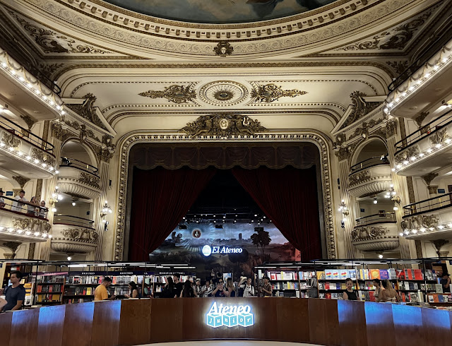
In passing, our guide told us about El Ateneo, a former theatre saved from demolition by a company that transformed it into a four-storey bookstore, according to National Geographic, the most beautiful in the world. We had coffee and tea there, just enjoying the atmosphere, but it set us back $11.50, double what it would cost back home, and left us wondering how ordinary Argentinians are able to make a go of it. Homelessness is rampant on the streets, protests are frequent, and petty crime has risen to alarming levels, threatening the future of the tourist industry. A woman staying in our hotel was mugged just a few blocks away. But the beauty of the bookstore made us forget all that.

As is my habit, I’ll end the blog series for this trip with a few observations:

  1. On this trip, I used the Airalo app for the first time. Free wifi is not readily available in South America. Airalo provides a way to buy mobile data in virtually any country in the world. I had to upgrade my iPhone to a version that’s eSIM-compatible, but I needed to replace my ancient iPhone 8 anyway. I twice bought 5GB on a 30-day plan for $55. Set up is not too difficult and the whole process is easier than buying and installing a SIM card for each country. Also, I will use WhatsApp more often, now that I’m familiar with its features.
  2. We visited five countries on this trip. All have different currencies. The Argentinian currency is worth 715 to $1 Canadian; the Bolivian = 5 per $CDN; the Chilean = 707 per $CDN; the Columbian = 3,190 per $CDN; and the Uruguayan = 30 per $CDN. It’s hard to keep straight. The trick is to exchange enough $US to meet your needs for the local currencies and hope for the best. Unfortunately, we had to burn through more $US than we planned to in Bolivia since many places did not take VISA. On Rapa Nui, we had to make an emergency trip to an ATM since our hotel’s credit card machine did not work at all.
  3. Use Uber instead of a taxi. You know how much your ride will cost before you order the car. Rides are available 24-7 and usually arrive within 5 minutes. The app has your credit card information and charges it directly, so you don’t need any cash. No negotiating with a cranky taxi driver who doesn’t understand English and no risk of credit card fraud. After your ride, you get an email asking you to rate the driver and to tip on the app if you wish.
  4. We encountered very few people in South America who could carry on a conversation in English. This was frustrating at the best of times and downright annoying when we needed help. The biggest surprise was in Cartagena, a popular tourist destination, where we had a hell of a time communicating. Google Translate saved us on many occasions and I wouldn’t travel without it.
  5. We’re both in our eighth decade and, although not slowing down that much, we tire more easily when things get hectic. For example, on this trip, we had 20 “moving days”. A moving day involves packing, carrying and unpacking suitcases and backpacks. Airports and hotels with no elevator get tiresome after awhile. The next time we travel, we’ll certainly keep this in mind, and it reminded us of why we like cruising so much.
  6. We hadn’t been on a Holland America cruise since the fall of 2019. We’d heard that the level of service had declined post-COVID but that certainly was not our experience. We felt at home, our room was spacious and well laid out, and the food was excellent.
  7. If anyone were to ask me where I’d like to travel next, I’d tell them someplace tourists from China have yet to discover. That those places are becoming fewer and farther between makes me rather sad.


Sunday, 8 December 2024


SOUTH AMERICA – PART 5

After five days on Rapa Nui, we laid over in Santiago for a day and spent our second visit there just hanging around downtown mostly, watching the frantic Saturday traffic on pedestrian streets and on Plaza de Armas. We did check out one tourist attraction, San Cristobal, a hill located in the center of the city that affords a nice view from all angles. We wandered around the summit and dropped into the beautiful church there, listening to prayers and watching nuns assembled for the occasion take cellphone photos and videos of the altar and one another! As Jos Denis was fond of saying: « C’est ça la société d’aujourd’hui! ».

Next morning, we headed to San Antonio by Flixbus. By 1:00, we were in our cabin aboard the Oosterdam, cruise #7 for us on the Holland America line. After a full month on the go, we were glad to finally unpack our suitcases and get some serious laundry done. The ship is certainly a step up from other ones we’ve sailed on; it’s bigger, has more amenities, and our room is the nicest inside cabin we’ve had so far. We felt at home right away! The photo below shows Santa’s Village. All the buildings are made of gingerbread, and it smells heavenly!

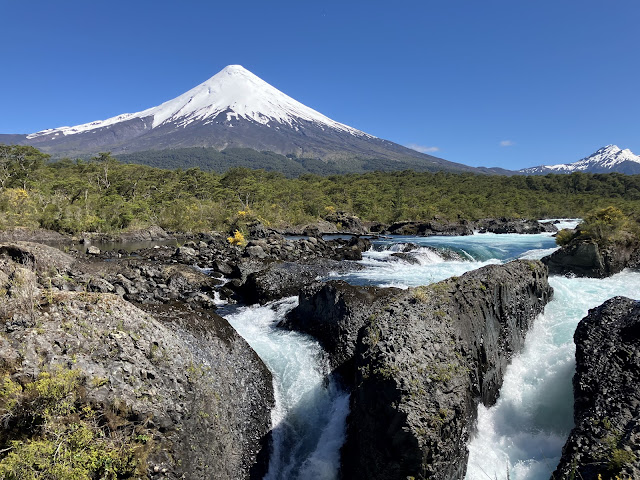
The Oosterdam sailed southward to our first stop, Puerto Montt, a port city about the same size as Charlottetown. We tendered ashore and made our way to the tourist information desk where a helpful guide told us where to find an ATM and how to get to our car rental location by taxi. One hour later, we were on our way to the lake district and Petrohué Falls, skirting the southern shore of Lago Lanquihue as we went. The falls may not be the biggest or the highest we’ve seen but the setting is absolutely spectacular. The photo below shows the falls with the enormous Orsono Volcano in the background. Depending on your perspective, either Orsono looks like Mt. Fuji, or Fuji looks like Orsano.

Leaving the National Park, we drove the scenic road around the rest of the lake, stopping for a bite in the pretty town of Puerto Octay. Much of this part of Chile was settled in the 1800s by German immigrants, and you can tell by the style of the older commercial buildings, houses, and farmsteads. The rolling countryside is characterized by very rich pastureland and large herds of beef cattle. I must also mention that the forests are spectacular. We dropped our Suzuki off around 2:00, having seen all that was on our list and more. The day cost us about $120 CDN, including taxi, car rental, highway tolls, park entrance fee, parking, and lunch. A similar Holland America excursion would have set us back $560! It was one of those days when everything went right. The Canadiens even won a rare game in overtime on a goal by Captain Nick Suzuki!

Our next port of call was Puerto Chacabuco, a tiny town with a population of about 1,200. As one gentleman I walked with to catch the local bus to nearby Puerto Aysen remarked: “I suppose they have to stop somewhere!”. As experienced cruisers, we’ve gotten used to ports like these that have not much to offer except a good walk. It was raining when we arrived and raining when we left but we had a good day, nonetheless. As often happens, the smaller ports are the most welcoming. The local military band was playing a few tunes – very well I might add – outside the tiny but functional cruise terminal. We walked to the center of town and took a local bus to nearby Puerto Aysen, population 28,000. It cost $6 return for the two of us and we felt sorry for passengers who paid big bucks for tours on a miserable day. Others may have gotten cheated by unscrupulous taxi drivers who always hang around port entrances looking for victims. I got a haircut and caught up on some work using the terminal’s excellent wifi. Not a bad day for all!

We spent almost two full days cruising the Chilean fjords between Puerto Chacabuco and Punta Arenas. The mountainous terrain on both sides of the vessel reminded us of Norway. Others have said it’s a lot like a West Coast cruise in British Columbia and Alaska. On the morning of the second day, we started seeing more snow on the mountains as we sailed further south. The Oosterdam slowed so that we could get a closeup view of the Brujo Glacier, shown in the second photo below.

We sailed south until the Oosterdam entered the Strait of Magellan, arriving early in the morning at Punta Arenas, Chile’s most southerly city with a population of 130,000 or so. We’d rented a car and walked to Europcar to pick it up. We had time to take a short walk in the Magellanes National Reserve before heading southwest on the main road. We didn’t go all the way to where it ends but we did get a good idea of what the coastline looks south of the city. Back in Punta Arenas, we walked part of the pretty seaside promenade which features statues and artwork. From there, we drove to the cemetery, a can’t-miss attraction with some of the most impressive mausoleums you’ll see anywhere. The photo below shows two of them.

I wanted to see the replica of Hernando de Magellanes’ (Ferdinand Magellan’s) ship, the nao Victoria, the first ship to successfully circumnavigate the world. Five ships left Seville, Spain in August of 1519 and sailed south across the Atlantic. It took them three years to complete the voyage and only the Victoria made it home. The replica is to scale, and one is free to wander around, including below decks. I can’t imagine how over 40 men could survive in such tight quarters. Next to the Victoria is a replica of the H.M.S. Beagle, the ship Charles Darwin sailed on in 1831. His observations during the voyage led him to develop his theory of evolution.

Both men’s stories were important to me in my formative years; Magellan because he was the first to sail around the world and Darwin because he helped me appreciate the folly of the Catholic Church’s creation story. Even at 7 years old, I couldn’t get my head around the idea that the universe was created in six days! Tracing Magellan’s journey on the school map in Wellington made me dream of travelling to far-flung destinations although, in truth, I never imagined I’d make it this far.

Punta Arenas turned out to be a pleasant surprise. It’s clean and modern and the people are very friendly. For reference, December 7 here is like June 7 in the Northern Hemisphere weatherwise. As for latitude, Puerto Montt is about as far from the South Pole as Charlottetown is from the North Pole, and Punta Arenas is as far south as Hopedale in Labrador and Grande Prairie in Alberta are north. The days here are very long, with sunrise before 6:00 sunset well after 10:00. The photos below show one of many shipwrecks along the coast near Punta Arenas and the lovely, wooded walk we took in the Magellan National Reserve.

Between Punta Arenas and Ushuaia, we sailed through that part of the Beagle Channel called “Glacier Alley”. It was a foggy morning, but the views were nonetheless impressive.


Thursday, 28 November 2024


SOUTH AMERICA – PART 4

It was nice to get below 4,000 meters for a change to Sucre’s elevation of 2,800. Sucre, population 360,000, holds major national importance as an educational and government center, and it contains one of the best preserved Hispanic colonial and republican historic city centers in the Americas. The city has been designated as a UNESCO World Heritage Site and holds an important place in Bolivian history as the first capital of Bolivia before the fall of silver's importance as a global mineral commodity. Our hotel, Hostal Sucre, was housed in the former residence of a wealthy family from the Spanish colonial period that dates from the 1500s. The photo below shows the courtyard; the place has a lot of charm.

On Day 7, we strolled around downtown Sucre with our guide to see the highlights before boarding a bus to see the world’s largest collection of dinosaur footprints. The tracks were discovered in 1995 by a cement company mining limestone. The now almost vertical wall was once wet ground near a lake and paleontologists believe various species of dinosaurs walked there to drink water. Tectonic action is responsible for pushing the horizontal sediment layers to the position they’re in today. The photo below shows the tracks of a sauropod, a herbivore that walked on four legs at this very place more than 65 million years ago!

The Parque Cretacico includes a nice interpretive centre but, like other Bolivian tourist attractions, the infrastructure around the site is very basic. That evening, our group dined at a fancy restaurant. We paid for the guide’s dinner and we both had steak; the bill came to $63.35! A meal like that would have cost us $300 back home.

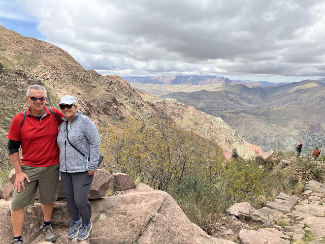
On Day 8, we left the hotel early bound for a hike on part of the Inca Trail. It was mostly downhill for 4.5 kilometers and the views were fantastic.

On Day 9, we took a couple of short flights from Sucre to get us back to the trip starting point, La Paz, and said our goodbyes before everyone went their separate ways. I truly hope that Bolivia will survive the current political and economic unrest and someday achieve its potential, for the sake of the people who are suffering through the crisis. The Bolivian example shows yet again that socialism cannot work. The country has isolated itself and will need “friends” to climb out of this mess. It's not hard to imagine why foreign investment is lacking in Bolivia, since the government can take control of a company’s assets with the stroke of a pen.

As for tourism, the potential is there in the form of world-class attractions like the Uyuni Salt Flats, the dinosaur footprints, and the Inca Trail, to name just a few. But the lack of adequate infrastructure and all the negative publicity about what’s happening in Bolivia will deter people from visiting.

After two days of hard travel, we landed in Santiago, capital of Chile, and spent a relaxing day there. Chile is a developing country with a high-income economy compared to its neighbours, Colombia, Peru and Bolivia, and is one of the most economically and socially stable nations in South America. Chile is a long, narrow country bordered by the Andes Mountains in the east and the Pacific Ocean the west, and its shape reminds me of a razor clam (coutelier), complete with the foot, Tierra del Fuego, at the bottom. The distance from North to South in Chile is about the same as the distance from East to West in Canada. Chile’s per capita GDP, the best measure of economic well-being, ranks it below Uruguay, but above Argentina and well above Colombia and Bolivia.

Santiago is Chile’s biggest city, with a population of about 7 million, almost half the country’s total. The city center is by far the nicest we’ve seen on this trip, and Plaza des armas is a lovely place to spend a Sunday afternoon people watching, which is exactly what we did. There are many pedestrian streets and a bustling central market, together with high-end stores and lots of shops. The Metropolitan Cathedral, located on Plaza des armas, is a very imposing and impressive building, inside and out. The contrast between this country and the previous two we’ve visited is striking. People here are far more relaxed, probably because they’re not struggling to survive day-to-day.

Easter Island (Rapa Nui) is but a tiny speck in the vastness of the Pacific Ocean and its isolation makes one wonder how humans ever found their way here. The island is one of the world's most remote; the nearest inhabited land is Pitcairn Island, population 60, 2,075 kilometres (1,289 mi) away. The nearest point on the South American continent lies in central Chile, 3,512 km (2,182 mi) away. That’s about the distance between Charlottetown and Winnipeg. Rapa Nui was a “bucket list” destination for me. We had planned to include it in a fall 2020 South American tour, but COVID put the kibosh to that. It’s not an easy place to get to but, after three hard weeks on Intrepid tours, we needed a break in a more relaxed setting.

Oral history and archaeological evidence suggest that Polynesians arrived here from the Marquesas or the Cook Islands around 1,100 AD. Europeans first arrived in 1772 and brought with them devastating diseases for which the local population had no immunity. The island also has a history of slave abductions. By 1867, less than 1,000 islanders remained from a population estimated at 15,000 at its height, before European contact.

The island is small, just a bit bigger than La Région Évangéline (163 sq km vs. 130), but it’s packed with interesting things to see. We arrived at the tiny airport early afternoon after a five-hour flight and checked into our modest lodgings before taking a stroll through downtown Hanga Roa, the only sizeable settlement, with a population of about 7,500. It’s a touristy place but not overrun like so many we’ve been to, and it didn’t take us long to find our first Moai. These five overlook Hanga Roa.

On Day 2, we explored Hanga Roa on foot before picking up our rented Suzuki 4WD, and headed out for an orientation drive. It took us about five hours to drive the main roads and make our way around the Island. Along the way, we stopped to see the best of the Moai sites, Ahu Tongariki, Ahu Nau Nau, and Te Pito Kura. The first one features a line of fifteen statues, the second has five complete statues, four with top hats, and the third is a toppled Moai thought to be the tallest on the Island when it was standing. But my favourite is the lone Moai (third photo) that overlooks the line of fifteen; he‘s the most fearsome looking.

More than 900 Moai have been identified. They were carved out of volcanic rock (tuff) and erected on platforms (ahus) from the time of first settlement until about 1500. The tallest is 10 meters high and weighs over 80 tonnes! Easter Island’s National Park is of course a UNESCO World Heritage Site. After a delicious meal of empanadas, we ended our Day 2 watching the sunset at Orango, the southwest tip of the Island.

Day 3 began with a hike around the crater of Rano Kau, an extinct volcanic near Hanga Roa. The crater is almost 1.6 km wide and is hard to fit into a single photo.

From the crater, we drove toward the eastern end of the island to the place called Rano Raraku, another extinct volcano. What makes this site so important is that it supplied the stone for 95% of the Moai on Rapa Nui. There are many incomplete statues in the quarry, and some are located high on the crater wall, making them almost inaccessible. It’s hard to imagine why the Rapa Nui spent so much of their resources carving these massive statues weighing many tonnes, how they transported them to all corners of the island, and how they erected them. Many of the Moai at Rano Raraku are incomplete and were left in place for reasons that are not fully understood. Downslope of the quarry are several that are partially buried to their shoulders in the spoil from the quarry.

Archaeologists believe the statues were a representation of the ancient Polynesians' ancestors. The Moai face away from the ocean and towards the villages as if to watch over the people. Although the exact method of moving the Moai from the quarry to their resting places is the subject of speculation, it is generally believed that they were “walked”. Teams of workers would have worked to rock the upright Moai back and forth, securing it with ropes, creating the walking motion and holding the moai upright. This is consistent with the natives’ oral history. Whatever the true answer, it remains an amazing engineering feat. The first photo shows Elva standing beside several Moai that are partially buried at the quarry at Rano Raraku and the second shows the slope from a distance.

Rapa Nui turned out to be just the relaxing break we needed. We enjoyed going off by ourselves without a guide and without a schedule. The people here are kind, considerate, and laid back. The streets of Hanga Roa are not very busy, no one seems in a rush, no one leans on the horn to express their frustration, and one eventually gets used to the nighttime barking of stray dogs and the crowing of jealous roosters. If it wasn’t so far off the beaten track, we’d come back. But then, that’s probably what has kept this treasure the way it is, and it’s best that it stay that way.

There is however one major flaw in Rapa Nui’s tourism product. Most of the important sites are in the National Park. It costs $112 CDN per person for a park pass which is steep enough, but here’s the kicker. You can’t visit any of the National Park sites without a guide, and that will cost you another $100 CDN per person per day. That just doesn’t work for independent travellers like us. We’ve experienced enough guided trips to know that we don’t like them; too much useless information from a know-it-all who won’t stop talking. It’s a great make-work strategy but not one we like.

Over the past month, I’ve lost two acquaintances, former neighbour Bobby MacKay and travel companion Dr. Dave Crocker. Although very different in their lifestyle choices, both were good and capable men, men who had plans, and who never imagined that the end would come when it did. It’s a good lesson. Carpe diem!

Tuesday, 19 November 2024

 SOUTH AMERICA – PART 3

Bolivia is a large land-locked country bordered by Colombia, Peru, Brazil, and Chile, and it has a population estimated at 12 million. It is about the size of Ontario, and one-third of the country lies within the high Andean plateau. Bolivia is a developing country, the second poorest in South America. Its economy is based on agriculture, forestry, mining, and goods such as textiles and clothing, refined metals, and petroleum. Bolivian mines produce tin, silver, wolfram, borax, lithium, and copper.

Bolivia’s Gross Domestic Product per capita is about $4,000, half of Colombia’s. The contrast between the two countries is striking: infrastructure is very basic, women line the sidewalks selling basic goods and junk food, the public education system is poor and, although health care is public, it is poorly developed and delivered.

To an uninformed outsider like me, Bolivia appears on the verge of economic and political collapse. In La Paz and on our way to Uyuni, we passed endless lines of trucks waiting to buy fuel. Dozens of the trucks waiting in line were petroleum tankers needing fuel to pick up their loads. The bus driver for the first day of our Intrepid  tour waited six hours to fill his tank with diesel.

Bolivia’s central reserves are dangerously low, meaning essentially that the country is on the verge of bankruptcy. The surest sign of this is that everyone wants $US and they’re willing to pay a premium above the official rate to get them. Loss of confidence in a country’s currency is the first sure sign of an economic crisis in the making. Although things were quiet when we visited, there have been massive demonstrations in La Paz and, in some parts of the country, protesters are blocking the main roads. The place is ripe for revolution.

It took us eight hours by bus to get from La Paz to Uyuni, 540 kilometers. Along the way, we saw crushing poverty: dogs eating garbage left on the side of the road; mud brick houses with no electricity; and farm fields parched from lack of rain. Uyuni, population 30,000, is the main transportation hub for the movement of goods between La Paz and Potosi in Bolivia, and across the Chilean and Argentinian borders. But its main claim to fame is as the gateway to the Uyuni Salt Flats. Each year, 60,000 or so visitors from around the world come to experience them, and that’s why we were here. The photos below show mud brick structures at one of our rest stops and a herd of domesticated llamas.


The next morning, we were up bright and early to drive to the Uyuni Salt Flats. But first, we stopped at the train museum, a rather decrepit collection of locomotives and coal cars from the steam era. Still, it was fun climbing onto a couple of the old girls, which of course I did. I counted 49 Toyota Land Cruisers in the parking lot, tourists all headed for the same place we were.

The vastness of Uyuni Salt Flats is hard to describe, let alone imagine. They cover 12,000 square kilometers, an area twice the size of Prince Edward Island and are of the purest white. The salt is several meters thick and is underlain by a brine rich in lithium, a very valuable mineral used in the production of batteries. There is talk of exploitation elsewhere but Bolivia will insist on local processing before it allows foreign interests to invest.

We drove about 200 kilometers during the day, stopping at the former salt hotel (of course made of salt), and at a rock outcrop called Incahuasi. We climbed to the top past massive giant cacti and got a 360-view of the flats below.

That evening, we slept at a “hotel” in the very small community of San Juan. While a few brave souls make a living growing quinoa, I suspect the hotel is a major employer since there were 30 guests the night we were there.

On Day 3 of our excursion in the wilds of southwest Bolivia, we drove across another salt flat, this one brown in colour, and our 25-year-old Toyota suffered a major breakdown. We watched in amazement as our driver and the two others who were travelling with us dismantled a major engine system and got her going again in jig time.

The highlight of the day was seeing flamingos in several locations, feasting on shrimp growing in waters that few organisms can live in. The water must be very salty but the birds were thriving. We saw three species in the same lagoon: Andean, Chilean, and Lesser, plus some ducks and seagulls. The scenery on this day was spectacular as we drove across dirt tracks mostly, our driver skilled enough to navigate the Paris-Dakar Rally if given the chance. He seemed to know every rut and pothole. The photo below shows where we crossed the railway tracks. Do you see the road? That’s because there isn’t one.


I can usually use Google Maps to retrace a route we’ve done on a given day, but Days 3 and 4 are impossible to find because the “roads” we drove on are not marked. We stayed our second night in a hostel in the tiny hamlet of Huayllajara, population 100. Next morning, I got up bright and early and took a picture of the local grocery store at sunrise. I wasn’t feeling very well so decided to go for my morning constitutional to get things moving, as it were. Shit happens they say. The highlight of the day for me was a dry fart!

Day 4 took us south along the border with Chile to the extreme southwest corner of Bolivia where we saw geysers and fumaroles in an area of volcanic activity. Geothermal energy is in its infancy here but at least the country is getting a start.

After a relaxing dip in a hot spring, we began the long drive back to Uyuni, again over dirt tracks. We made a few stops along the way, including this one at an interesting rock formation. If this were in North America or Europe, it would be a major tourist attraction, but we had the place to ourselves. Our guide told us that we drove 1,000 km during our three-day Uyuni excursion. No more than 50 of that would have been on paved highways and maybe 300 or maintained gravel roads; the rest was off-road. 

Our group of twelve, six Aussies, four Swiss, and us, are all seasoned travellers and range in age from early 30s to early 70s (that’s us!). Half of the group had hiked the Inca Trail before flying to La Paz, so they were accustomed to the altitude. Altitude sickness is not pleasant: headache, dizziness, shortness of breath, upset stomach, and dry mouth and nose. The sun in the Bolivian desert is intense. The three-day journey from Uyuni to southwest Bolivia requires one to be in good health and ready for many inconveniences. 

We’re glad we did it, but we also realize that we’re nearing the end of difficult journeys like these. Our guide, Wendy, takes very good care of us, testing our blood oxygen level twice a day to make sure we’re safe and checking regularly to see that we’re OK. A reading below 80% means your body can’t get enough oxygen to keep your organs and muscles functioning and, for an Intrepid traveller, it means you’re leaving the tour. A couple came close, but we all managed to hang in there.

Day 5 began with a four-hour ride on a public bus from Uyuni to Potosí, a city of 850,000 that was founded by the Spanish in the 16th century to mine silver. It was one of the largest and richest cities in the world in its heyday. Our guide, Wendy, led us on a walking tour of the historic center, declared a UNESCO World Heritage Site for its colonial era buildings. We had lunch at a beautiful café overlooking a city square and had dinner together at a fine local restaurant. 

On Day 6, we pulled up stakes again, this time on a four-hour bus ride to Sucre where we will spend the next couple of days before ending our tour in La Paz on Saturday.


Wednesday, 13 November 2024


SOUTH AMERICA – PART 2

On Day 9, our last day in Medellin, we booked a guided tour with a private tour company. The guide met us at the door to the hotel saying, “solo Español”. Since no one else on the bus spoke English, we had to figure things out for ourselves. Mostly, we just followed along. Fellow passengers were from other parts of Colombia, as well as Puerto Rico, Costa Rica, Honduras and El Salvador. The bus ride to Guatapé took about two hours with a couple of rest stops along the way. The whole tour cost $72 for the both of us, and included a sandwich stop and a hot lunch!

There isn’t a lot to do in Guatapé, a town of 5,000 or so, but a nearby attraction is well worth the trip: the climb up El Péñon de Guatapé. The bus dropped us off in the parking lot and the guide told us they’d be back in an hour, enough time to allow me to climb to the top. Elva wasn’t feeling it that day, so I climbed the 706 steps to the viewing platform by myself. Us old guys take comfort in small victories: I didn’t stop to rest, and no one passed me! I was lucky that the rain held off just enough for me to take in the views. I had a nice chat with a couple of guys from Ireland and headed back down to meet the rest of our group.

After a nice lunch in Guatapé, we drove back towards Medellin and took a 45-minute boat ride on the Peñol-Guatapé Reservoir. Along the way, we passed by the ruins of one of drug lord Pablo Escobar’s retreats, today a haunting and tacky tourist attraction.

The drive back to Medellin took an hour longer than expected due to a massive traffic jam. As is the case in so many other cities, infrastructure is not keeping up with population growth. People are pouring in from surrounding areas, squatting on land high in the surrounding hills and living in terrible conditions, homelessness is widespread, and sex tourism is on the rise. While Medellin is an interesting place to visit for a few days, it isn’t a place we’d come back to.

We rose bright and early on Day 10 for the short flight to Cartagena, population 900,000. The city lies on the Caribbean and has an interesting history. The presence of indigenous peoples dates to 4,000 BC, and the Spanish established the first European settlement here in 1533, making it one of the oldest in the Americas. As a former Spanish colony, it was the key port for the export of silver and gold from the interior and for the import of enslaved Africans. Today's Cartagena is a vibrant tourist destination, welcoming many cruise ships on Caribbean itineraries.

After checking into our hotel in the district of Getsemani, Santiago led us on a walking tour of the old city, a UNESCO World Heritage Site featuring a colonial walled city and fortress. Unlike other places we visited in Colombia, Cartagena is hot. Stinking hot! It had rained early in the day, some streets were flooded, it was 30 degrees C, and the humidity was at 86%. By the time we got back from our walk (10,000 steps or so), I was cooked!

Cartagena resonates with salsa—there’s no other way to describe it, as it’s one of the world’s capitals for dancing and enjoying this Caribbean-rooted musical genre. It’s impossible not to move your feet and hips to some of the classic salsa songs. We listened to live music at the Plaza de la Alduana inside the old city walls. Cartagena celebrated its Fiestas de Independencia the weekend we were there. We had dinner in a very nice restaurant, our last as a group, and Elva and I headed back to the hotel around 9:00 while the young folks went back for more salsa. At breakfast the next morning, we said our goodbyes. This was our fifth trip with Intrepid, and the best group we’ve travelled with so far.

We’d decided to spend two extra days in Cartagena before travelling to La Paz. Little did we realize that the Independencia celebration would continue, and this time in the Getsemani neighbourhood where our hotel was located. The cacophony began in the late afternoon – loud music and firecrackers – and continued until sunrise the next morning. The street party was like New Orleans’ Mardi Gras on steroids! Thank goodness for good earplugs.

On Day 3 in Cartagena, we walked to Bocagrande, the city’s modern quarter and took a long walk along the beautiful beach. Were we to return here for a visit, we’d stay there rather than in the old quarter. We set the alarm for 2:00 am to give us enough time to get to the airport for our 5:00 am flight. I woke just in time to learn that it had been cancelled.

A travel day can go well, and it can go south. Ours only got worse! Our travel agent, Brett Tabor of Maritime Travel, tried to book us a mid-afternoon flight from Cartagena to Bogota so that we’d be sure to get on the 9:30 pm flight to La Paz. The airline, Avianca, refused to help. So, we headed to the airport at noon and went to the Avianca “Special Services” desk to change our booking. No one spoke English. They finally booked us on a 5:13 flight. It left 90 minutes late. We had just enough time to get to our gate for the La Paz flight. Instead of arriving in La Paz at 2:30 pm on November 12, we arrived at 3:30 am the next day. Shit happens! Three lessons learned: patience, stamina, and NEVER fly with Avianca again. 

A few parting comments about Colombia. If you’re hesitating because of the country’s recent turbulent past, don’t. It’s beautiful, the people are friendly and accommodating, and everything is cheap; one-third to one-half less for hotels, meals, Uber, and everything else. We stayed in three of the bigger cities, Bogota, Medellin, and Cartagena, and never felt unsafe. Our Intrepid tour was first-rate. The only thing we’d recommend is to spend more time in the smaller cities, those with populations of 50,000 or less.

Birders keep lists and so do travellers. Bolivia will be country #100 for us. Growing up in Wellington, I’d never have imagined we’d visit even 10! To be fair, the sovereignty of two of the countries we’ve included on our list is disputed. Prince Edward Island could declare its independence, but it would mean nothing if that independence was not recognized by sovereign countries, which of course it wouldn't. As an example, Taiwan’s sovereignty is recognized by only 11 of the United Nation’s 193 member states. Palestine is recognized by 143 of the UN’s member states. Both Taiwan and Palestine are recognized by Vatican City as sovereign states although the Vatican is not a UN member. So, answering the question: “How many countries have you visited?” is not as simple as it may first seem.

To make things even more complicated, some “country list keepers” count sub-national entities or states that are self-governing. For example, Saint-Pierre-et-Miquelon, Guadeloupe, Polynésie française, and Saint-Martin, though technically French overseas territories, are counted by some as countries. Same goes for self-governing entities like the Cook Islands. Places like Gibraltar, Hong Kong, Puerto Rico, and American Samoa are counted by some, but I choose not to. So, bottom line, I count Taiwan and Palestine on our list, and that makes Bolivia country #100.

After a few hours of fitful sleep, we had breakfast at our hotel, Qantu. A night here costs $63 CDN, and the room is the nicest we’ve had on this trip. I went for a short walk and got my first taste of downtown La Paz, a chaotic sight reminiscent of the poorer Central American countries. In my first South America blog, I stated that Bogotà is the world’s highest capital city at 9,000 feet. That was a mistake; the title is held by La Paz at 12,000 feet. We experienced oxygen deprivation as soon as we got off the plane.

On our only day in La Paz, we took a guided tour of the city and surrounding area. The old part of the city lies in a valley; it has expanded high into the surrounding hills and continues to do so. Double-decker buses are not our style but, since we were tired and just wanted to get out of the hotel, we thought it would be a good option. And, at $24 CDN each for four hours, it looked like a deal. The tour turned out to be better than expected and we got to see more of La Paz than we ever would have on our own. The first photo is of us with La Paz in the background and the second is of a garden at the Valle de la Luna, just outside the city.

Later, we met our twelve-member Intrepid group for introductions and an evening meal. Tomorrow, we hit the road for the city of Uyuni where we’ll stay a night before heading to the nearby Salt Flats where we’ll spend a few days off-grid sleeping in dormitories. They told us to bring our own toilet paper!